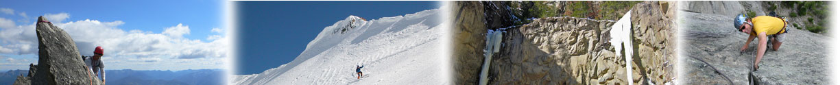
Dan Oldenberg and myself headed to Tom Miner Basin and Ramshorn Peak in search of some ice to climb, specifically the Dry Creek drainage. I thought the area might have some potential when I saw it in Sept. hunting. I went back in Oct. only to find a few patches of ice but it looked promising later in the season. Wednesday, we left the Tom Miner Campground trail head at 8am and hiked the trail towards Buffalo Horn Pass until it intersected Dry Creek. We then bush wacked up the frozen creek until we encountered the first ice bulge at about the 8000 foot level. We soloed the first several small bulges (10-30 feet each) until we came to a super fun 60' fat pillar (WI3) which Dan led. We soloed several more steps (10-40 feet) at WI3,M3 until encountering the final short curtain (40 feet WI3+) which I led. We then slogged up and out of the drainage and joined the SE ridge of Ramshorn at about 9800 feet and hiked the trail back to the car in right at 8 hours.
This was a pretty fun route in a great location in SW Montana. Although no single pitch was very long most of the steps are vertical and we figured to have climbed about 350-400 feet of technical ice. The less snow the better as some of the lower angle slabs will probably fill in. I recommend this route as a fun, low commitment solo or as an enjoyable ice route with an alpine feel in a pretty cool area that sort of has a "Cody" feel to it. If a new route we name it [i]Full Curl.[/i]
We never did make it to the climbs that I initially scouted as climbing the creek itself kept us happy. There is certainly more route potential in the Dry Creek Drainage as we looked at two 60-80 foot pillars that just hadn't quit touched down yet. There are also several side drainages that had ice, how good and how much is hard to say.
[img]http://montanaice.com/forums/user_images/Ramshornfirstpitch.JPG[/img]
[img]http://montanaice.com/forums/user_images/LastPitch.JPG[/img][i][/i]
![http://montanaice.com/forums/user_images/LastPitch.JPG[/img][i][/i](http://montanaice.com/forums/user_images/LastPitch.JPG[/img][i][/i)
- Log in to post comments
New Route on Ramshorn?